EyeSoar provides drone-supported powerline inspection services for utility teams, contractors, and infrastructure professionals who need clear aerial visual data without relying only on ground-level review or difficult manual access.
FAA Part 107 Licensed | Insured | Based in Robinson, IL
Powerline infrastructure can be difficult to inspect from the ground. Poles, lines, crossarms, insulators, transformers, and related equipment often require elevated views to document clearly. Drone-supported aerial inspection gives utility teams and contractors another way to capture useful visual data while helping reduce unnecessary climbing, difficult access, or extended time in the field.
Inspecting utility infrastructure traditionally involves sending crews up poles, staging bucket trucks, or working near energized lines — all of which come with real safety considerations and scheduling constraints.
Drone-supported aerial inspection offers a way to collect clear visual data on line conditions, hardware, and equipment without the same access challenges. EyeSoar captures high-resolution photos and video that your team, engineers, or maintenance staff can review to plan next steps.
This is not a replacement for qualified utility professionals — it is supporting documentation that gives your team more to work with before committing to crew deployment or repair planning.
EyeSoar captures aerial photos, video, and supporting visual data that qualified utility or infrastructure teams can review as part of their inspection, maintenance, or documentation process.
Visual documentation of pole conditions, attachments, and visible physical concerns along a line route.
Aerial photos of conductors, insulators, connectors, cross-arms, and line hardware for visual review.
Close-range aerial imagery of transformers, switches, and mounted equipment to support condition assessment.
Overhead aerial documentation of substation layouts and visible equipment conditions.
Aerial overviews of vegetation encroachment, access conditions, and ROW corridors along line routes.
After storms or outages, aerial photos provide a fast first look at affected areas before crews are dispatched.
Drone-supported inspection gives utility and infrastructure teams another way to review assets, document conditions, and identify areas that may need closer attention. Instead of relying only on ground-level visibility or difficult manual access, aerial visuals can support safer planning, clearer records, and more efficient field review.
Capture elevated perspectives of utility assets that may be difficult to see clearly from the ground.
Drone-supported documentation can help reduce unnecessary climbing or difficult access when a visual review is the first step.
Aerial photos and videos provide dated visual documentation that can support maintenance planning, project review, and internal communication.
Drone inspection support can help teams review lines, poles, or project areas more efficiently before deciding what follow-up work is needed.
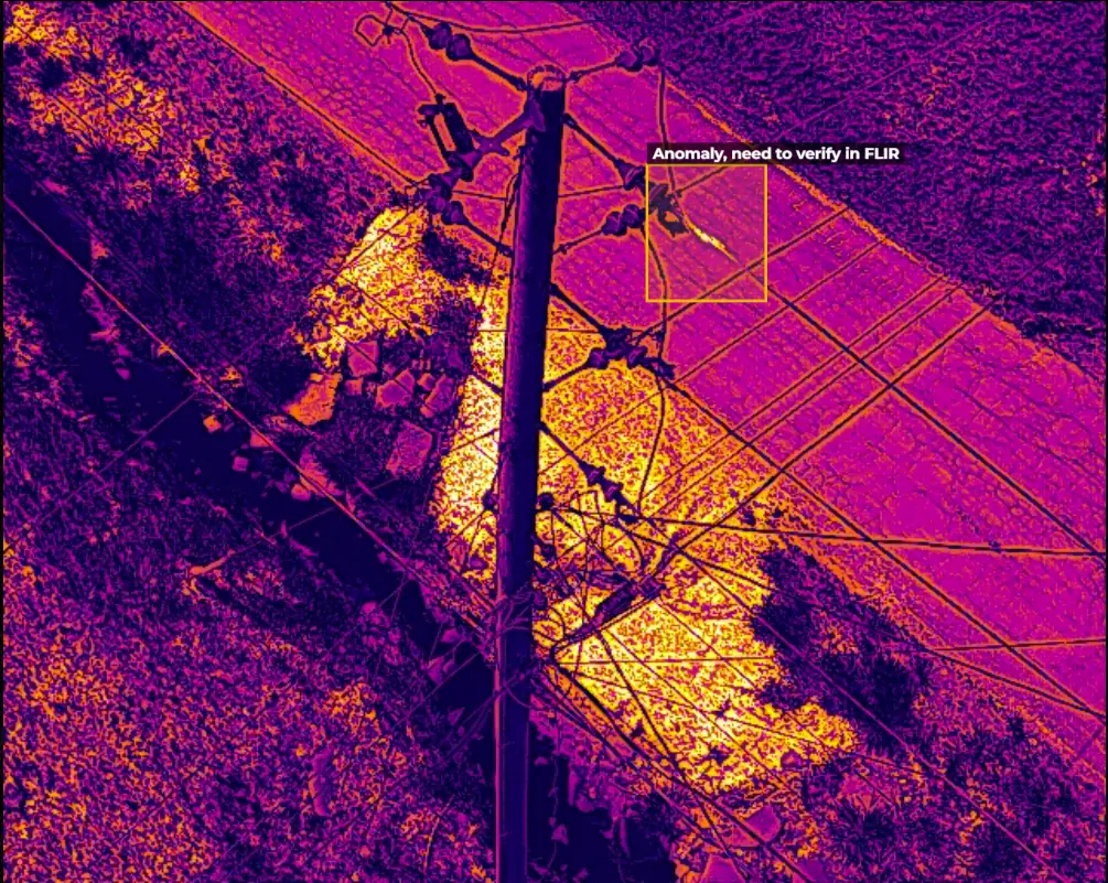
When appropriate, EyeSoar can provide aerial thermal imaging support to help capture potential heat patterns around utility infrastructure. Thermal imagery can be useful for identifying areas that may need closer review by qualified utility or maintenance professionals.
Thermal imaging does not replace qualified inspection, testing, or engineering review. It provides supporting visual data that can help teams identify where closer evaluation may be needed. And is intended to be of further assistance in preventative maintenance.
EyeSoar supports organizations that need clear aerial documentation of utility infrastructure, project sites, and hard-to-access assets. Whether the work involves planned maintenance, storm review, project documentation, or internal field review, our drone-supported visuals help qualified teams see more before deciding the next step.
Regional utilities that need to inspect aging infrastructure, document conditions, or plan maintenance without full crew deployment every time.
Contractors who need pre-job site documentation, post-construction aerial photos, or progress documentation for client review.
Operations and maintenance teams looking for a faster way to get a visual on line conditions before scheduling field work.
Every project starts with understanding the site, the infrastructure involved, and the type of visual data your team needs. From there, EyeSoar plans the flight, captures the requested aerial documentation, and delivers organized visuals your team can review, share, or use for planning.
Yes. EyeSoar works with the client team to understand the site, project scope, access points, and any required safety protocols before flying near utility infrastructure. We follow applicable FAA regulations and safe operating practices, and we do not fly in a way that creates unnecessary risk near energized lines or equipment.
No. EyeSoar provides aerial visual documentation, including inspection photos, video, thermal imagery when appropriate, and supporting visual data that your qualified engineers, utility staff, or maintenance team can review. We do not provide certified engineering reports, official inspection findings, or regulated utility condition assessments.
EyeSoar can capture aerial visual data of poles, lines, crossarms, insulators, transformers, visible hardware, access areas, vegetation concerns, storm impacts, and surrounding site conditions. The goal is to provide useful visual documentation that supports maintenance planning, project review, and follow-up decisions by qualified professionals.
Visual data is typically delivered through a shared folder or file transfer in an agreed-upon format. Depending on the project, deliverables may include aerial photos, video clips, thermal images, or organized visual documentation. Delivery preferences are discussed during the project review phase.
It depends on the scope, location, weather, airspace requirements, and current availability. For standard corridor inspections or planned maintenance documentation, contact EyeSoar as early as practical. For urgent post-storm, outage, or damage review needs, reach out directly and we will discuss what may be possible.
EyeSoar is based in Robinson, IL and provides powerline drone inspection support across East Central Illinois and West Central Indiana. We serve clients near Crawford County, Terre Haute, Vincennes, Oblong, Newton, Hutsonville, and surrounding communities. For projects outside the typical service area, contact us to discuss the location, scope, and logistics.
Tell us about your line route, the infrastructure you need documented, and your timeline. We will follow up to discuss the project.