EyeSoar provides drone mapping services for construction sites, agricultural land, properties, and project areas that need clear aerial visual documentation. Based in Robinson, IL, we help clients across East Central Illinois and West Central Indiana capture mapping visuals that support planning, review, documentation, and decision-making.
FAA Part 107 Licensed | Insured | Based in Robinson, IL
Ground-level photos can only show part of the picture. Drone mapping provides a broader aerial perspective of a site, property, or project area, helping clients see how different features, structures, and work areas relate to one another. By capturing consistent overhead imagery, teams can gain a clearer understanding of site layout, access routes, visible conditions, project progress, and changes that occur over time.
For construction projects, aerial mapping can help document ongoing work, monitor site development, and provide visual records that are easier to review and share with stakeholders. In agriculture and land management applications, drone mapping can offer a more complete view of fields, drainage patterns, property features, and general land conditions. Property owners, developers, and project managers can also use aerial mapping visuals to support planning discussions, evaluate site conditions, and maintain organized documentation throughout a project’s lifecycle.
Rather than relying solely on scattered photos taken from the ground, drone mapping creates a more comprehensive visual record that can improve communication, support decision-making, and provide valuable context for future reference.
EyeSoar captures drone-based mapping visuals that help clients document sites, review conditions, and communicate project information more clearly. Depending on the project, mapping support may include orthomosaic-style imagery, 2D aerial mapping visuals, 3D visual documentation, and organized aerial photos.
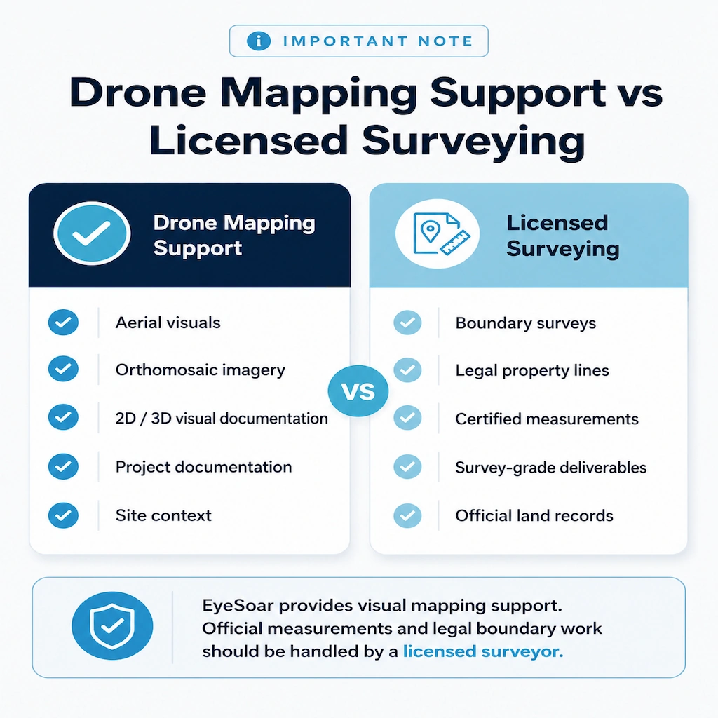
These deliverables are designed to support planning, review, and documentation. They are not a replacement for licensed land surveying, engineering review, or legal boundary documentation.
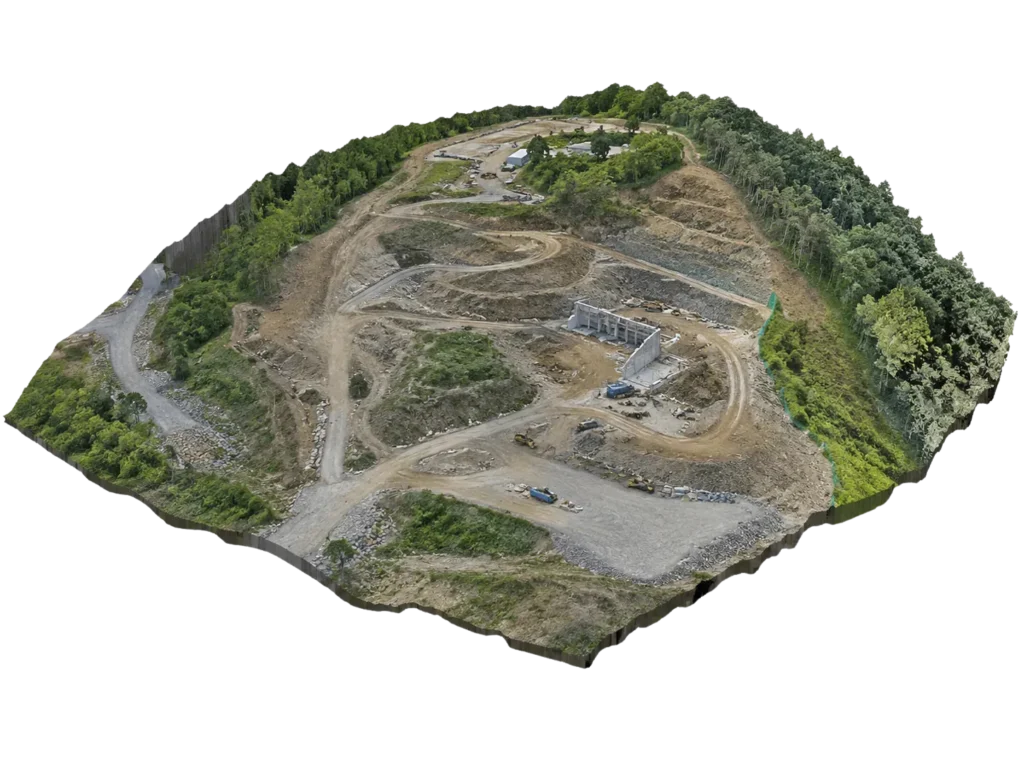
From the same flight data, EyeSoar can generate 3D point clouds and surface models that show terrain elevation, structure profiles, and site topography in a visual format your team can navigate and review.
3D mapping visuals are useful for stockpile estimation, grading documentation, construction progress review, and project presentations — providing a clearer spatial picture than photos alone.
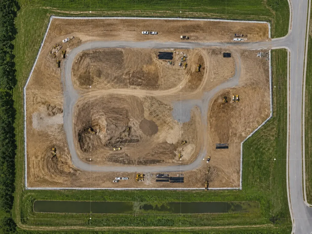
EyeSoar captures overlapping aerial photos that are processed into a georeferenced 2D map — called an orthomosaic — giving you a high-resolution, top-down view of a site or property.
2D mapping is commonly used for construction site documentation, agricultural land review, property overviews, and project planning where a clear, scaled aerial view adds value.
These are aerial mapping visuals for documentation and project support — not certified land surveys. If your project requires licensed surveying, a qualified surveyor should be involved.
Drone mapping services can support a range of project types where aerial visuals make the site easier to understand. EyeSoar focuses on practical mapping support for clients who need useful documentation, not unnecessary complexity.
Drone mapping can help document site progress, access areas, material locations, grading activity, and changing project conditions over time.
Aerial mapping support can help landowners and agriculture teams review fields, property areas, drainage patterns, access routes, and general land conditions.
Drone mapping visuals can support property review, site planning, project discussions, and internal decision-making for land, commercial properties, and rural project areas.
2D drone mapping can provide a clear overhead view of a site or property, helping clients understand layout, context, and visible site conditions.
3D mapping visuals can help clients better understand site features, terrain, structures, and project areas from multiple angles.
Aerial mapping can create dated visual records that support progress tracking, project communication, maintenance planning, and future reference.
Drone mapping gives clients a clearer way to see and document project areas from above. Whether the goal is planning, progress tracking, land review, or project communication, aerial mapping visuals can make complex sites easier to understand.
Aerial mapping provides a wider view of project areas, properties, and land conditions than ground-level photos alone.
Drone mapping visuals create organized records that can support planning, progress review, and communication between teams.
Drone-supported mapping can help capture larger properties, construction areas, or rural sites more efficiently than relying only on ground-level documentation.
Mapping visuals can be shared with project teams, property owners, contractors, or qualified professionals who need a better view of the site.
Drone mapping can provide useful aerial visuals, site documentation, and mapping support, but it does not replace licensed land surveying, engineering review, or legal boundary work.
EyeSoar does not provide certified boundary surveys, legal survey documents, engineering reports, or survey-grade land measurements. When a project requires official measurements, property boundaries, legal documentation, or engineering decisions, clients should work with the appropriate licensed professional.
EyeSoar’s role is to provide aerial mapping visuals and supporting documentation that can help clients better understand and communicate project conditions.
EyeSoar supports clients who need aerial mapping for project documentation, planning, land review, or progress tracking. Our drone mapping services are designed for practical field use across construction, agriculture, property, and infrastructure-related projects.
Drone mapping can help document jobsite progress, site layout, access routes, grading activity, and changing project conditions.
Aerial mapping visuals can support field review, land documentation, drainage observations, and rural property planning.
Drone mapping can help property owners and developers review land, document site conditions, and communicate project details more clearly.
Mapping visuals can help contractors review project areas, document progress, and share site context with clients or team members.
Aerial mapping support can help document building sites, lots, access areas, surrounding land, and property conditions.
Drone mapping visuals can support documentation of corridors, access areas, utility sites, and surrounding project conditions.
Every drone mapping project starts with understanding the site, the project goal, and the type of visual documentation needed. From there, EyeSoar plans the flight, captures the aerial data, and delivers organized mapping visuals for review.
No. Drone mapping can provide useful aerial visuals and site documentation, but it is not the same as licensed land surveying. EyeSoar does not provide legal boundary surveys, certified survey documents, or official land measurements. Projects that require legal boundaries or survey-grade deliverables should involve a licensed surveyor.
Drone mapping can support construction documentation, agriculture and land review, property planning, progress tracking, site condition records, and project communication. It is useful when clients need a clearer aerial view of a site, property, or project area.
An orthomosaic map is a stitched aerial image made from multiple drone photos, corrected to create a more consistent overhead view of a site. It can help clients review site layout, visible conditions, access points, and project context from above.
Yes. Depending on the project scope, EyeSoar can provide 2D drone mapping visuals, 3D visual documentation, and organized aerial imagery. The deliverables are discussed before the flight so the project is planned around what the client actually needs.
Mapping visuals are typically delivered through a shared folder or file transfer in an agreed-upon format. Depending on the project, deliverables may include aerial images, orthomosaic-style visuals, 2D mapping visuals, 3D visual documentation, or supporting project files.
EyeSoar is based in Robinson, IL and provides drone mapping services across East Central Illinois and West Central Indiana. We serve clients near Crawford County, Terre Haute, Vincennes, Oblong, Newton, Hutsonville, and surrounding communities. For projects outside the typical service area, contact us to discuss the location, scope, and logistics.
Tell EyeSoar what you need mapped, documented, or reviewed, and we’ll follow up to discuss the project scope, location, deliverables, and whether drone mapping is the right fit for your needs.